Publications
Geoscience and earthquake insurance relation: a methodology to calculate premium based on density map of earthquake occurrence in West Java
Authors: Mordekhai, Faisal Anggoro
01 November 2019
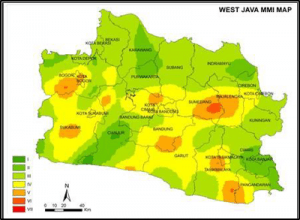
Earthquake insurance is an insurance that covers the risks that occur when buildings are damaged/destroyed due to an earthquake. In order to determine adequate premium for earthquake insurance, a grouping method based on building locations is needed. In Indonesia, the method for grouping the building locations is based on zones where several locations have not been classified to the district/municipality level. In other words, the zone grouping system still has a limited resolution. In addition to detailing the grouping, this paper also aims to make the level of earthquake vulnerability in West Java. The approach used is to make a density map based on earthquake intensity scale (MMI) and magnitude historical data. From these density map, the value of building exposure damage are calculated using the Mean Damage Ratio (MDR) parameter. This value is used as a pricing parameter for determining earthquake insurance premiums in more detail for each location. The results of this study indicate that the levels of damage to buildings are varied and earthquake insurance premiums have a high degree of non-uniformity in each municipality/district in this province.
Read More...